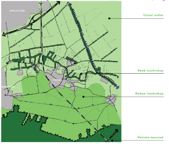
Area characteristics
The area lies in the transition area between the Veluwe Ridge (moraine, high, dry) and IJsselvallei (erosion valley, low, wet). The area lies on the eastern flank of the Veluwe moraine and a Enken and Beekdal landscape. The location on the flanks of the Veluwe and the presence of stream valleys have shaped the development and identity of the area. In the figure below is illustrative of the situation of the diverse landscapes in the area.
Beekbergen and Loenen owe their existence and development to a large extent to the specific characteristics of the soil and water landscape. The flank-villages with open or villages with open, lying on the slopes of the ash / enk. From the heaths (sod, manure) and stream valleys (hay, manure) were centuries nutrients to the ash / enken. These were so slowly transformed into convex / rolling farmland with a degree black layer (thick black enkeerdgronden).
The hilly terrain of the moraine slopes and various stream valleys are still striking and recognizable elements in the landscape. The variety of terrain with sand deposits and river valleys has been a favorable condition for occupation.
Subsoil, soil and water
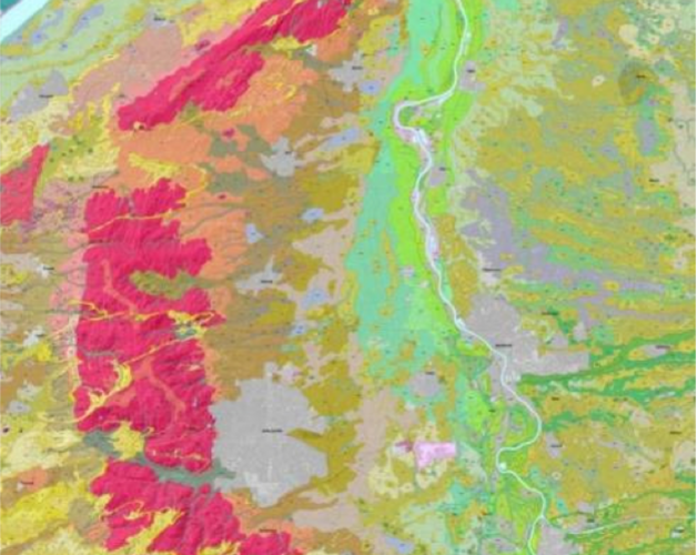
Geologically the IJsselvallei is due to the activity of glaciers, 200,000 to 125,000 years ago. During the Ice Age land ice marched in from the north, through the valley of the river IJssel. When a bulldozer the ice floated the surrounding material sideways and upwards. Thus arose moraines, including the Veluwe. By the end of the Ice Age melted the ice and meltwater flowed out of the Veluwe. In addition, the moraine ridge was buffed; pebbles, gravel and coarse sand were moved by water to give the map below valley left by the ice. weather which landforms are located in the outskirts of Apeldoorn.
In later glaciations Netherlands remained outside the reach of the ice, even the permanently frozen subsoil. Soil Shifts occurred at that time, which thawed grofzandig material of the moraine slope afschoof. That led to further reduction in height between moraine and valley. In some periods of the Ice Age it was even colder and there was less snow, so even dry rivers fell. Under those circumstances, it was shown the wind drum on the bottom. It occurred on large sand drifts. On the moraine slope formed accumulations of fine sand, Pleistocene sand deposits, which were dispersed by the wind. Thus, the slope dekzandvlaktes arise and we take towards the valley dekzandruggen and -opduikingen to. After the Ice Age the rivers came back to life. Only in the Bronze Age and Roman times over the river should be to function as tributary of the Rhine. East of the Pleistocene sands cover put IJssel material off, ranging from fairly coarse river sand dune close to the river (levees) to heavy clay in the bowls behind the levees. Where water stagnated (in the cups and in the stream valleys) originated locally peat. Through all these processes exhibit the bottom of the IJsselvallei a striking transition pattern, from west to east dammed river sands, rinsed and issued slid moraine sands, sand deposits and clay and sand deposits of the IJssel succession. Thus arose high to low landforms in the planning area which we now describe as Veluwe Veluwe and IJssel Valley. The Apeldoorn Canal is roughly the border between Veluwe and IJssel Valley. The Veluwe has mainly groundwater and small streams to the edge. These are often dug / dug and called sprinkle.